This blog is about our experiences enjoying and maintaining our 1980 Silverton 34C powerboat.
Showing posts with label Polar Navy. Show all posts
Wednesday, December 25, 2013
Polar Navy
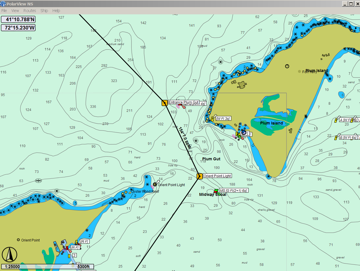
Sometimes on a cold winter afternoon, it's fun to plan a cruise or, as we have done here, set up a route that we can use on our Netbook computer when we're underway.
The navigation software that we've been using for the past couple of years is made by Polar Navy and it comes in two pieces: PolarView (the chart application shown here) and PolarCom, which is a simulated set of navigation instruments that can be set up to show Heading, Speed Over Ground, Distance Covered, etc. In fact, you can set PolarCom up to display virtually any information you have available in NMEA 0183 (or NMEA 2000, I believe) format.
Here's the PolarCom application running over PolarView. Here at home, we don't have any GPS input so it's showing the default, Current Position, Speed over Ground and Course, all of which are zero. The default instrument size is somewhat big, but you can make it smaller and move it around, out of the way, on the chart by just dragging it.
PolarView costs just $39.95 and PolarCom comes with it for free. That purchase gives you a license to download any of the ENC or Raster charts whenever you want to. You also get three seats, so that you can load it onto a home PC and perhaps a laptop, as we have done.
If you create a route for an upcoming cruise at home, PolarView makes it easy to export that data (via an Excel .csv file) to a flash drive and then later, import the data onto your boat computer.
PolarView is also integrated with Active Captain data so you can click on an Active Captain point-of-interest and read what other Active Captain members have said about it.
You can name the routes and the individual waypoints and waypoints can be shared between routes. Once a route leg is established, PolarView shows you its distance and relative bearing to the next waypoint, which is really useful.
We use our little Acer Netbook and a small puck-type GPS receiver while underway. Our boat's position is shown on the chart at any scale we choose, making it easy to follow a particular planned route without leaving a snake-wake in the ocean behind us.
Sure, all of this can be done with multi-function navigation displays but they cost a lot more than we're willing to invest. We use a Standard Horizon chartplotter that gets its GPS info from an external antenna and sends waypoint data to our old reliable Furuno radar, but the PolarView chart display on our computer is so much easier to read and from what we can see, the GPS position is also more accurate.
It is also really tedious to plan a route on the Standard Horizon plotter with its little joystick. Now we plan the route using PolarView and then just key in the coordinates of the waypoints in on the chartplotter.
The first screen-grab photo above shows Plum Gut, one of of favorite 0.88 miles of water. We've probably been through there 200 times and we don't really need those waypoints but, there were those times when the fog was so heavy that...
But we all have our fog stories so we won't bore you with ours.
Sunday, September 29, 2013
Indian Leap
We were rewarded this weekend with cool, dry weather and a nice warm sun. We should have planned a cruise, but the weather is never certain at this time of the year and frankly, we didn't know how nice it was going to be until Saturday morning arrived.
The whole gang on A-Dock was there and everyone wanted to just sit on the dock and enjoy what could be some of the last great days of our boating season. Our marina was putting on an "OctoberFest" event on Saturday night and everyone was looking forward to it.
Everyone headed up to the big tent at 6 PM, but we elected to have dinner on board instead. Frances cooked fish and one of our favorite vegetable concoctions and we had a fine time. After dinner, yours truly elected to hit the sack and read a book. Frances joined our dock neighbors and had quite a good time dancing, we understand. We also heard that she eventually joined the band to play the bongos.
On Sunday morning, we decided to take a walk up the Yantic River to the falls, also known as "Indian Leap." It's a long walk but the City of Norwich maintains a beautiful walking path along the river and it is well worth doing, especially at this time of year. You can walk north as far as the falls (pictured above). The history of that odd name is described on a sign just as you near the falls. Hopefully, you'll be able to read it here.
We haven't visited the falls in several years but every time we do, we marvel at how beautiful it is, all right within the confines of the City of Norwich.
We put two 1/4-20 bolts through the bottom of the radar base. The new platform (also 3/4" plywood) is attached to them using two wing nuts.
The Acer Netbook only weights 1 lb. so the new platform handles the weight easily.
We considered adding edges to keep the computer from sliding off but Frances came up with some of that plastic matting that keeps the computer from moving anywhere.
We didn't want to trust the Acer to run on its own battery. It came with a cigarette lighter power cable so we cut that end off and wired it into the boat's DC electrical system. We also added a switch so we could turn that power on and off.
The computer also needed a GPS signal and we used a small USB puck antenna (made in China, unfortunately) that plugs in and is recognized immediately. I think we paid $15 for it. It seems to give us better accuracy than the external marine GPS antenna used by the Standard Horizon chartplotter.
The only drawback to our little GPS puck is that it has a magnet on the back meaning that it has to be kept away from the compass. We slipped it out under our bridge enclosure and it worked perfectly without affecting the compass.
Here's the computer showing us at the marina in Norwich, exactly where we should be.
The software running on the Acer is Polar View from Polar Navy. Google it if you are interested in this type of application or just cruise planning (polarnavy.com). It is far ahead of our Standard Horizon chartplotter and unlike Standard Horizon, it doesn't boot with a message warning me that our charts are outdated and that we need to buy new ones from them. Of course, there's no way to update the charts without getting them on a SIM card from them.
With Polar Navy, you buy the Polar View software (around $50 if I remember correctly) and then from within Polar View, download any and all the charts you need. No extra charges apply for the charts. You even get three seats (installations) so you can plan at home and on your boat.
Polar View knits the charts together perfectly and you can turn on or off as much chart information as you like. Even on the little Acer Netbook, it allows very fast scrolling and changes of scale.
To use this for navigation underway, you load Polar Com, which is included. Polar Com handles the communications between the GPS receiver and the software and it even comes with a neat little dashboard that shows data such as COG, SOG and heading.
Thanks to Jeffery Siegal and his wife Karen from Active Captain for the tip on Polar Navy. Jeff is one of the most knowledgeable marine software developers on the planet and to make it even better, he lives on and runs a trawler with his wife Karen and his two dogs.
We wondered how visible the charts would be in bright sunlight and we tested at several times of day. We could see the charts quite easily although when we were taking pictures, we did get some annoying screen reflections. We don't think that will be a problem when we are underway.
The whole gang on A-Dock was there and everyone wanted to just sit on the dock and enjoy what could be some of the last great days of our boating season. Our marina was putting on an "OctoberFest" event on Saturday night and everyone was looking forward to it.
Everyone headed up to the big tent at 6 PM, but we elected to have dinner on board instead. Frances cooked fish and one of our favorite vegetable concoctions and we had a fine time. After dinner, yours truly elected to hit the sack and read a book. Frances joined our dock neighbors and had quite a good time dancing, we understand. We also heard that she eventually joined the band to play the bongos.
On Sunday morning, we decided to take a walk up the Yantic River to the falls, also known as "Indian Leap." It's a long walk but the City of Norwich maintains a beautiful walking path along the river and it is well worth doing, especially at this time of year. You can walk north as far as the falls (pictured above). The history of that odd name is described on a sign just as you near the falls. Hopefully, you'll be able to read it here.
We haven't visited the falls in several years but every time we do, we marvel at how beautiful it is, all right within the confines of the City of Norwich.
Our Navigation Table
For some time, we've wanted to augment our marginally effective Standard Horizon chartplotter with computer-based navigation. We have a small Acer Aspire Netbook that we bought several years ago for less than $200 (thanks for Frances for always finding the best deal on anything). It doesn't have a hell of a lot of computing power but is it small and light. Frances has used one with an air card as her home PC on the boat for least two summers without any issues.
The problem was, where would be put a small computer like this on our bridge? Our helm has no room for anything more than what is there now. Even our chartplotter is mounted on the side of the helm on a bracket we made. To mount our radar display, we had to use a helm seat mount. We know it looks odd but it gives us a great view of the radar whether we are standing or seated.
We began to think about making the plywood base under the radar display big enough to also hold the Netbook computer. That would work but it would also be nice if the computer platform was removable. After more than a few measurements and sketches, we designed an extension that would nest against and mount to the 3/4" plywood base under the radar display.
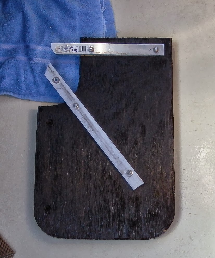
Here's what we came up with: The supports are 1/4" aluminum bar stock that we had on hand. The ends are shaped to fit up against the spider on the radar mount. The table itself is made out of 3/4" plywood and treated with CPES and several coats of black paint. Since had everything in our garage, our cost for this was zero.
We put two 1/4-20 bolts through the bottom of the radar base. The new platform (also 3/4" plywood) is attached to them using two wing nuts.
The Acer Netbook only weights 1 lb. so the new platform handles the weight easily.
We considered adding edges to keep the computer from sliding off but Frances came up with some of that plastic matting that keeps the computer from moving anywhere.
We didn't want to trust the Acer to run on its own battery. It came with a cigarette lighter power cable so we cut that end off and wired it into the boat's DC electrical system. We also added a switch so we could turn that power on and off.
The computer also needed a GPS signal and we used a small USB puck antenna (made in China, unfortunately) that plugs in and is recognized immediately. I think we paid $15 for it. It seems to give us better accuracy than the external marine GPS antenna used by the Standard Horizon chartplotter.
The only drawback to our little GPS puck is that it has a magnet on the back meaning that it has to be kept away from the compass. We slipped it out under our bridge enclosure and it worked perfectly without affecting the compass.
Here's the computer showing us at the marina in Norwich, exactly where we should be.
The software running on the Acer is Polar View from Polar Navy. Google it if you are interested in this type of application or just cruise planning (polarnavy.com). It is far ahead of our Standard Horizon chartplotter and unlike Standard Horizon, it doesn't boot with a message warning me that our charts are outdated and that we need to buy new ones from them. Of course, there's no way to update the charts without getting them on a SIM card from them.
With Polar Navy, you buy the Polar View software (around $50 if I remember correctly) and then from within Polar View, download any and all the charts you need. No extra charges apply for the charts. You even get three seats (installations) so you can plan at home and on your boat.
Polar View knits the charts together perfectly and you can turn on or off as much chart information as you like. Even on the little Acer Netbook, it allows very fast scrolling and changes of scale.
To use this for navigation underway, you load Polar Com, which is included. Polar Com handles the communications between the GPS receiver and the software and it even comes with a neat little dashboard that shows data such as COG, SOG and heading.
Thanks to Jeffery Siegal and his wife Karen from Active Captain for the tip on Polar Navy. Jeff is one of the most knowledgeable marine software developers on the planet and to make it even better, he lives on and runs a trawler with his wife Karen and his two dogs.
We wondered how visible the charts would be in bright sunlight and we tested at several times of day. We could see the charts quite easily although when we were taking pictures, we did get some annoying screen reflections. We don't think that will be a problem when we are underway.
Subscribe to:
Posts (Atom)